Manaus, Embrapa - ACONVEX - T0a
Sitios.Manaus-Embrapa History
Show minor edits - Show changes to markup
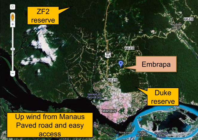
The site is located up-wind from Manaus-AM, Brazil, inside the campus of Embrapa Amazônia Ocidental. Because of its location, this site is usually called "Embrapa", but in publications the term ACONVEX site is preferred, except when referred to as part of GoAmazon2014/15 where it is known as T0e.
The site is located up-wind from Manaus-AM, Brazil, inside the campus of Embrapa Amazônia Ocidental. Because of its location, this site is usually called ```Embrapa''', but in publications the term ACONVEX site is preferred. When referenced as part of GoAmazon2014/15, it is identified as T0e.
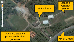
Localização do sítio experimental Embrapa, no KM30 da rodovia AM-010
This experimental site was implemented near Manaus in 2011 and will run continuously during the next years applying a synergy of different instruments to help understanding the interactions and feedback mechanisms between humidity, convection, clouds and aerosols. It was initially implemented by FAPESP AEROCLIMA thematic project but received contributions from FAPESP CHUVA, from Amazonian Dense GNSS Meteorological Network (Adams et al., Atmos. Sci. Let. 2011), and more recently from the .
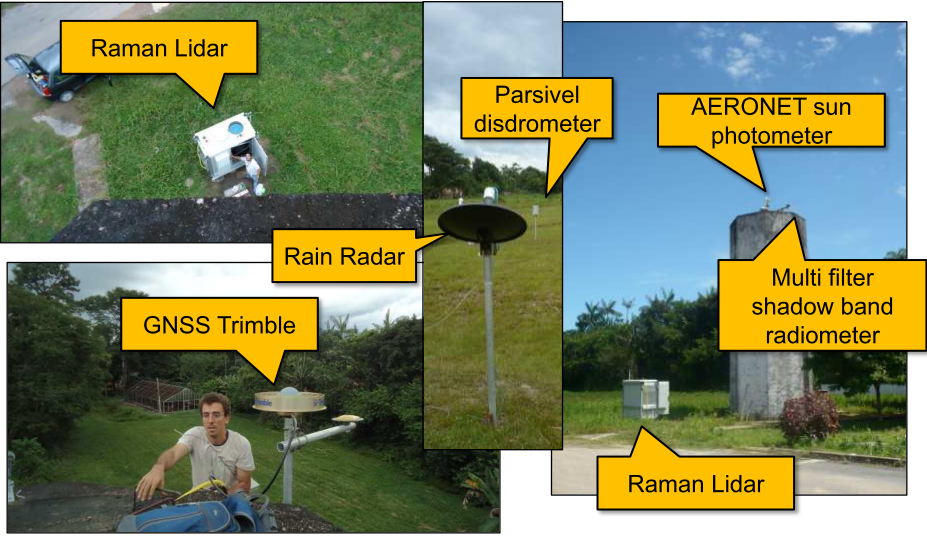
The site is located up-wind from Manaus-AM, Brazil, inside the campus of Embrapa Amazônia Ocidental. Instruments available, with installation date and project responsible, are listed below:
This experimental site was implemented near Manaus in 2011 and will run continuously during the next years applying a synergy of different instruments to help understanding the interactions and feedback mechanisms between humidity, convection, clouds and aerosols. It was implemented by the unfunded collaborative research project ACONVEX which stablished partnerships with the FAPESP AEROCLIMA thematic project, the FAPESP CHUVA thematic project, Amazonian the Dense GNSS Meteorological Network (Adams et al., Atmos. Sci. Let. 2011), and more recently from the .
The site is located up-wind from Manaus-AM, Brazil, inside the campus of Embrapa Amazônia Ocidental. Because of its location, this site is usually called "Embrapa", but in publications the term ACONVEX site is preferred, except when referred to as part of GoAmazon2014/15 where it is known as T0e.
Instruments available, with installation date and project responsible, are listed below:
This experimental site was implemented near Manaus in 2011 and will run continuously during the next years applying a synergy of different instruments to help understanding the interactions and feedback mechanisms between humidity, convection, clouds and aerosols. It was initially implemented by FAPESP AEROCLIMA thematic project but received contributions from FAPESP CHUVA, from Amazonian Dense GNSS Meteorological Network (Adams et al., Atmos. Sci. Let. 2011), and more recently from the Max Planck Institute
This experimental site was implemented near Manaus in 2011 and will run continuously during the next years applying a synergy of different instruments to help understanding the interactions and feedback mechanisms between humidity, convection, clouds and aerosols. It was initially implemented by FAPESP AEROCLIMA thematic project but received contributions from FAPESP CHUVA, from Amazonian Dense GNSS Meteorological Network (Adams et al., Atmos. Sci. Let. 2011), and more recently from the .
Este sítio experimental foi montado pelo projeto ACONVEX em parceria com os projetos AEROCLIMA, CHUVA, Dense GNSS Network e com o MPI. Fica localizado vento acima de Manaus, no km30 da rodovia AM-010 (Manaus-Itacoatiara) em um zona de moderado impacto antrópico.
(:Title Manaus, Embrapa - ACONVEX - T0a :)
This experimental site was implemented near Manaus in 2011 and will run continuously during the next years applying a synergy of different instruments to help understanding the interactions and feedback mechanisms between humidity, convection, clouds and aerosols. It was initially implemented by FAPESP AEROCLIMA thematic project but received contributions from FAPESP CHUVA, from Amazonian Dense GNSS Meteorological Network (Adams et al., Atmos. Sci. Let. 2011), and more recently from the Max Planck Institute
The site is located up-wind from Manaus-AM, Brazil, inside the campus of Embrapa Amazônia Ocidental. Instruments available, with installation date and project responsible, are listed below:
- 24 Ghz micro rain radar (MRR), MPI-M, May 2012
- Ceilometer, MPI-M, August 2012
- Metstation PTUV + radiation THIES, AEROCLIMA, April 2012
- Disdrometer THIES, AEROCLIMA, April2012
- 24 Ghz micro rain radar (MRR), CHUVA, August-September2011
- Davis met. Station, UEA-AM, July 2011
- Trimble GNSS Receiver/Vaisla met. Station, DenseGNSS, July 2011
- Multi filter shadow band radiometer (MFR) , AEROCLIMA, July2011
- Cimel sun photometer (AERONET), AEROCLIMA, February2011
- UV Raman Lidar, AEROCLIMA, July 2011
Os instrumentos que estão disponíveis são:
- radar de apontamento vertical?,
- raman-lidar? com canal de vapor de água,
- ceilômetro?,
- GNSS?,
- fotômetro solar? e
- radiômetro shadow-band?,
 \ -Localização do sítio experimental Embrapa, no KM30 da rodovia AM-010
Localização do sítio experimental Embrapa, no KM30 da rodovia AM-010
| Localização do sítio experimental Embrapa, no KM30 da rodovia AM-010 \ -Localização do sítio experimental Embrapa, no KM30 da rodovia AM-010 | Localização do sítio experimental Embrapa, no KM30 da rodovia AM-010 | Localização do sítio experimental Embrapa, no KM30 da rodovia AM-010 | Localização do sítio experimental Embrapa, no KM30 da rodovia AM-010 | Localização do sítio experimental Embrapa, no KM30 da rodovia AM-010 | Localização do sítio experimental Embrapa, no KM30 da rodovia AM-010 | Localização do sítio experimental Embrapa, no KM30 da rodovia AM-010 | Localização do sítio experimental Embrapa, no KM30 da rodovia AM-010 | Localização do sítio experimental Embrapa, no KM30 da rodovia AM-010 | Localização do sítio experimental Embrapa, no KM30 da rodovia AM-010 | Localização do sítio experimental Embrapa, no KM30 da rodovia AM-010 | Localização do sítio experimental Embrapa, no KM30 da rodovia AM-010 | Localização do sítio experimental Embrapa, no KM30 da rodovia AM-010 Localização do sítio experimental Embrapa, no KM30 da rodovia AM-010
| Localização do sítio experimental Embrapa, no KM30 da rodovia AM-010Localização do sítio experimental Embrapa, no KM30 da rodovia AM-010
Localização do sítio experimental Embrapa, no KM30 da rodovia AM-010
Instrumentos instalados em Julho/Setembro 2011
 | Localização do sítio experimental Embrapa, no KM30 da rodovia AM-010 | Localização do sítio experimental Embrapa, no KM30 da rodovia AM-010 | Localização do sítio experimental Embrapa, no KM30 da rodovia AM-010 | Localização do sítio experimental Embrapa, no KM30 da rodovia AM-010 Localização do sítio experimental Embrapa, no KM30 da rodovia AM-010
Localização do sítio experimental Embrapa, no KM30 da rodovia AM-010
Os instrumentos estão disponíveis:
Os instrumentos que estão disponíveis são:
Instrumentos instalados em Julho/Setembro 2011
Instrumentos instalados em Julho/Setembro 2011
\
Localização do sítio experimental Embrapa, no KM30 da rodovia AM-010
Localização do sítio experimental Embrapa, no KM30 da rodovia AM-010
|Localização do sítio experimental Embrapa, no KM30 da rodovia AM-010 Localização do sítio experimental Embrapa, no KM30 da rodovia AM-010
|Localização do sítio experimental Embrapa, no KM30 da rodovia AM-010 |Localização do sítio experimental Embrapa, no KM30 da rodovia AM-010 Localização do sítio experimental Embrapa, no KM30 da rodovia AM-010 \\
|Localização do sítio experimental Embrapa, no KM30 da rodovia AM-010 Localização do sítio experimental Embrapa, no KM30 da rodovia AM-010
Localização do sítio experimental Embrapa, no KM30 da rodovia AM-010 \\
Este sítio experimental foi montado pelo projeto ACONVEX em parceria com os projetos AEROCLIMA, CHUVA, Dense GNSS Network e com o MPI.
\\Este sítio experimental foi montado pelo projeto ACONVEX em parceria com os projetos AEROCLIMA, CHUVA, Dense GNSS Network e com o MPI. Fica localizado vento acima de Manaus, no km30 da rodovia AM-010 (Manaus-Itacoatiara) em um zona de moderado impacto antrópico.
\\ Sítio experimental Embrapa, no KM30 da rodovia AM-010
isso é um teste
aqui tambem
Localização do sítio experimental Embrapa, no KM30 da rodovia AM-010
Sítio experimental Embrapa, no KM30 da rodovia AM-010
Instrumentos instalados em Julho/Setembro 2011
- radar de apontamento vertical,
- raman-lidar com canal de vapor de água,
- ceilômetro,
- contador de CCN,
- GNSS,
- fotômetro solar e
- radiômetro shadow-band,
- radar de apontamento vertical?,
- raman-lidar? com canal de vapor de água,
- ceilômetro?,
- contador de CCN?,
- GNSS?,
- fotômetro solar? e
- radiômetro shadow-band?,
embrapa
Este sítio experimental foi montado pelo projeto ACONVEX em parceria com os projetos AEROCLIMA, CHUVA, Dense GNSS Network e com o MPI.
Os instrumentos estão disponíveis:
- radar de apontamento vertical,
- raman-lidar com canal de vapor de água,
- ceilômetro,
- contador de CCN,
- GNSS,
- fotômetro solar e
- radiômetro shadow-band,